Streamline GIS Service Detection with Ease
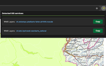
GIS Service Log is a free Chrome extension tailored for GIS professionals and developers. This tool automatically detects various GIS web services, including ArcGIS, WMS, WMTS, WFS, and XYZ tiles, as users browse mapping applications. Upon detection, the extension provides a user-friendly interface that displays a list of identified services, complete with direct links and a copy-to-clipboard feature, enhancing the workflow for professionals in the field. The extension's smart visual feedback, indicated by a color change in the icon, ensures users are aware of service availability in real-time.
The extension supports a wide range of service types and operates without any configuration, making it accessible for both seasoned developers and newcomers alike. Each tab in Chrome maintains its own service list, allowing for easy comparison across different mapping applications. With a clean, modern interface that includes automatic dark mode support and WCAG AA compliance, GIS Service Log is designed for efficiency and ease of use. Ideal for developers, educators, and IT administrators, this tool facilitates the exploration and auditing of GIS services, making it a valuable asset for anyone involved in web mapping.